|
|
|||||||
 |
|||||||
|
509/427-4181 • Fax 509/427-5260 © 2003, Riverside Graphics |
|||||||
|
|
|||||||
|
|||||||
|
509/427-4181 • Fax 509/427-5260 © 2003, Riverside Graphics |
|||||||
Scroll down to find bits about hikes, Search and Rescue missions and other stuff... or look here for SAR gear.
Most of the stuff in the woods happens in good old Skamania County, Washington. Extending from the bluffs on the north shores of the Columbia River Gorge, through the Cascade Mountains to Mount St. Helens, there is a wide range of terrain to provide seemingly endless opportunities for outdoor fun and adventure! Area map
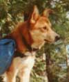 After nearly 15 years of devoted friendship, we bid a fond farewell to Rags...
Click for a bit more.
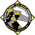 The 2002 State SAR Conference was held right here in good old Skamania County! It was a great deal of work for the Sheriff's Office, and Wind River SAR volunteers (along with regional teams who helped out - Thanks!), but the conference was a sucess - and everyone had a great time.
As the Air Ops Branch Director (under ICS), my job was to coordinate with the various agencies, and companies that provided aircraft for the SAR Air Ops training at the conference (and preconference).
Agencies that participated were: LifeFlight, Hillsboro Aviation, Coast Guard Group Astoria, 304th RQS, 36th Rescue Flight, and JL Aviation. We are very grateful for their help in making this happen!
Washington State SAR Conference '01
Each year Washington State hosts the largest Search and Rescue Conference in the world. This year Mason County hosted the event at their fairgrounds near Shelton, WA.
Part of the Conference are various demonstrations, and one of the most entertaining is that of the amazing rescue capabilities provided by helicopters. Without question, the most capable of them is the 304th Rescue Squadron from the 939th Rescue Wing in Portland, OR.
 Kathleen and I assisted in their demo as the ground SAR element... to say it was cool risks considerable understatement.
The call came about 6:20 pm for a man down with a dislocated shoulder, about a half mile up the trail to the Hot Holes.
By 7pm the first rescuers headed up the trail in the rain with a rope and blankets to catch up with, and relieve, the EMS folks who were taking the stokes stretcher in. This allowed EMS to hurry ahead to the patient. As more rescuers arrived, they grabbed additional ropes gear and headed up the river.
The trail to the Hot Holes (across the Wind River from the Carson Hot Springs Resort) has never been developed, and since the floods of '96, is mostly obliterated by landslides. This meant that after just about 1/10 mile, the best (!) way in was along the rocky riverbank.
The 210 lb. subject had fallen near the river at the base of a large (5+ acre) slope of big boulders. He was in a great deal of pain, and very cold when we got to him to begin packaging. We needed to get him up away from the river, across the boulders, and back down to the riverbank to carry him out.
 Planning and rigging for this took some time because of the terrain and limited man-power. The result was basically two anchors for belaying the stokes team at the apex of an inverted triangle. The stokes team would then lift the patient from rock to rock, while the belayers took up (or let out) the slack.
Once the riverbank was reached, three of the rescuers broke down the anchors, etc. and headed downstream to rig for a raising up to the last, useable 1/10 mile of trail. The stokes team continued to lift the patient from rock to rock - for hours. The uneven, wet, slippery riverbank seemed relentless. Two or three times the stokes team was able to actually walk with the stokes for maybe 20 feet before having to set it back down, and continue the process of lifting it from rock to rock...
With the rigging in place, the other 3 rescuers returned to help with the stokes - but as the night wore on, and we wore down - it became quite clear (in a bleary sort of way) that the 10 of us (plus 2 EMS types) were going to need additional help. Soon.
Our pathetic pleas were heard by base, and the fine folks of the Carson Volunteer Fire Department were page out at about 1 am.
By now, we were reduced to moving the stokes a foot or two, resting (collapsing) and then repeating the process. It would be difficult - no; impossible - to overstate the measure of relief felt when the flashlights of some 15 firefighters approached from the distant darkness!
About the time the help arrived, we had reached the point where a wheel could be clamped to the stokes, and the whole thing rolled along without having to carry the entire weight by hand (and back, shoulders and arms...). The sturdy presence of the firefighters made the raising, and final trundle to the parking lot almost anti climatic - it was a quarter to three in the morning.
 The next day, some of us returned to pick up some gear that had been left behind during the festivities of the night before, and to take a look at the terrain we had covered. Daylight revealed a rocky, mossy, dripping landscape that left us grateful none of the rescuers had sustained significant injury (like broken legs, ankles, etc.)... but someone had beat us, and our gear was already gone. So, if anyone reading this has any information - please, please, return our equipment.
We did, however, take the time to get some GPS data. Turns out the rescue which had occupied 8 painful hours spanned the distance of .4 miles - Gak.
4th of July, '00
The cell phone call came for a broken ankle on the Heartbreak Ridge trail - a steep cut trail off the Pacific Crest Trail (PCT) to the summit of Table Mountain.
Skamania County EMS and Wind River SAR responded to the Bonneville Dam PCT Trailhead where a SAR Base was established.
Based on a review of the map, and members knowledge of the area, it was decided to drive teams around to a saddle north of Table Mountain.
From there a Paramedic (a former USAF Pararescue type) and I headed (full gear, dead run) to the patient, while others began the difficult task of bringing the stokes stretcher, wheel and minimal rope gear to the scene.
We made fairly good time while on the PCT, but the Heartbreak Ridge Trail is steep - VERY steep! As we gasped and wheezed our way up this ridiculously steep, rugged excuse for a trail, we were evaluating various methods of extraction... none of them seemed to present any sort of simple, safe answer to the question: "Now what?"
Because of the danger to rescuers and patient in attempting an extraction without a full ropes rescue system (involving hours of gear and personnel transportation, etc.), a request was made to MAST (military air ambulance) for an airlift. We were advised that if MAST accepted the mission, we would be informed at, or before, takeoff - giving us the 40+ minute flight time from Ft. Lewis to prepare.
While the request was being processed, we continued with plan A (stokes extraction). The stokes and other gear began arriving at the scene, and patient packaging was underway when we were informed that MAST had accepted the mission, and was in route; ETA 25 - 30 minutes!
This gave us very little time indeed to complete the packaging, AND get the patient about 100 steep feet up the mountain to a small open area suitable for hoist operations.
A simple change-of-direction anchor was established just above the clearing, and sections of 1" tubular webbing joined, so that by walking down hill, about half the team could pull the other half - with the patient - up the hill. Quick and dirty, but we didn't have time for anything more elaborate...
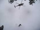
We had barely accomplished that, and were securing gear (and ourselves) when the BlackHawk vectored in on the GPS coordinates we had provided.
Hoist operations with a BlackHawk's intense rotor wash and thundering noise are inherently chaotic - add a steep, rocky, dusty mountainside and things get rather frisky!
Earlier I had asked the patient if she liked to fly...? The immediate "I HATE to fly!" did not bode well for what was to come...
So, I ventured... a helicopter ride doesn't really appeal to you...? "No."
(... oh, did I mention that little bitty detail about the helicopter not actually LANDING, per se, to pick you up... See, there's this cable...)
Well, now was not the time to dwell on that - I pulled my goggles down, jammed a foot and (I believe) one knee under the stokes to stabilize it, and pointed to the closest almost-flat-spot for them to lower the medic. This almost-flat-spot was a switchback in the trail, and, like an idiot, I must have had my mouth open - because as soon as his boot hit the trail - I got a mouthful of gravel, sticks and possibly a tree frog...
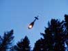
From there things moved quickly, a stokes was lowered from the helicopter, which then left to give us a break from the rotorwash while the patient was evaluated and packaged for the hoist.
The helicopter returned, lowered the cable, and the patient was hoisted in what must be a rather wild ride. The crew then lowered the 'jungle penetrator' which the medic rode back up - and off they went...!
Now I know these folks train and train for these sort of rescues, but it never ceases to amaze me the skill and professionalism with which they are accomplished - Wow.
With the hoist successfully completed, and the almost eerie lack of evidence that it had ever happened (except, of course, for the missing patient) we packed up and headed out - thankfully downhill - this time!
Mt. Adams - August '99
Often when out tromping about in this area, one is treated to views of snow capped peaks... among them is Mt Adams.
While I'm not the sort to go for mountain expeditions, Mt. Adams has always had a bit of an appeal... not so much an obsession as a nagging "one of these days..." sort of thing.
In fact, a feeble attempt had been made a couple of years earlier up the Southern "easy" Climb... which ended at the false summit when the decision was made (cool with me) not to push it through the effects of (no doubt mild) altitude sickness...
Enter Sandy Fraser, a member of Wind River SAR, and a former Navy Rescue Swimmer, Combat Medic, etc., etc., who overheard my passing comment of a fleeting interest in perhaps thinking about maybe someday considering the (however remote) possibility of climbing (or attempting to climb) the darn thing...
Well, from there it didn't take long for the momentum to build into definite plans to skip the Southern "weenie" (Ha!) Climb, and take a stab at the Northwest (gulp) Ridge.
So 4 pm one August afternoon found us headed up from the Killen Meadows Trailhead to spend the night (bivy sacks & sleeping bags) out under the stars at the base of Adams Glacier, in Killen Meadows. To say the night was gorgeous risks considerable understatement... the sunset over the Cascades, followed by the extraordinary brilliant crispness of the stars created the perfect start for the rest of the trip.
Crampons, ice axes, and practice self-arrests began the Adams Glacier bit of or trip. The plan was to wander across said glacier to the Northwest Ridge, and on up... however, after poking around some crevasses, we arrived at the conclusion that in fact we were not gonna make it over to the target ridge.
Hey, no problem... (echoed over the glacier) we'll just take the North Cleaver! Mind you, that is "cleaver" as in "meat cleaver."
For those Mountaineers out there reading this, I realize what we have here is a fairly straight forward route... but as one of those without much mountaineering experience – I freely admit to viewing this route with some trepidation.
Mt. Adams is basically a big (very big) pile of rocks, and the North Cleaver is a fairly sharp (often very sharp) ridge of this rock pile.
Well this seemed to go on forever... but as we were clambering around a particularly rocky part of this rock pile, it began to dawn on me that we were going to make it... like, to the summit and everything!!
Once we had made it over most of the frisky stuff, we stopped (for longer that a few gasping moments) to enjoy what seemed to be the end of the scary stuff – and the outrageous view.
There we blathered on a bit about the view, gibbered about the totality of the experience, glanced at the watch... and realized daylight had other plans.
So Mt. Adams remains unclimbed (at least by me (and if one discounts the hundreds who summit each year))... leaving that lofty goal intact for now.
The climb (declimb?) down was as uneventful as it was spectacular, or something like that – including the ever popular glissade (what we used to call sliding on our butts) across the glacier and snowfields.
Until the tree line rewrapped us in evergreen, I found my attention sneaking off in the direction of the Goat Rocks – but I'm sure its just a passing thing...
Full Moon 8/8 '98
After spending a pleasant afternoon sitting around the campsite of some friends near Goose Lake, we (Kathleen, Kent & I) left one vehicle at the top of Red Mt. and drove another to the Thomas Lake (111 @ 4000') trailhead of the Indian Heaven Wilderness Area.
Heading up the trail (in, of course, full search gear) at 8pm, we soon passed Thomas, Heather & Eunice lakes (4300') nestled in the timber. Twilight deepens and Brader Lake (4480') slips past.
Naha Lake (4760') brings us the serene magic of Indian Heaven's meadows, and campers at Rock Lake cautiously question our sanity for tromping about in the middle of the night.
An owl orbits us several times, setting the mood as we head south, past Lake Umtuz, drop into Blue Lake (4640') and the pre-moon darkness. Still without lights we are easily (!) mistaken for elk by some happy campers on the Pacific Crest Trail.
With the first fleeting bits of moonlight, the PCT sweeps us around the eastern flank of Gifford Peak and up to a saddle (4800') at the north end of Berry Mt.
Some 600' below to the west, Basin Lakes hide in the darkness, while to the east we catch our first views of the full moon as it climbs to dominate the night sky... this is getting fun!
After a bit of a break (Snickers, etc.) we switch back our way up Berry Mt. - from below large, widely spaced, yellow eyes reflect our lights from the deep dark. The languid, steady gaze, and the leisurely way they later moved off, hinted at a feline source... who knows, but whatever the critter, we were pleased to be sharing the night with it.
The mile-long ridge of Berry Mt (4900') shifted the trail from east to west for views of the Cascades in the silvery moonlight. To the east Mt. Adams seemed to glow beyond the forested ridges - Sleeping Beauty, Steamboat Rock & others. Mount St Helens' missing top dominates the western view, an eerie reminder of the often violent origins of the beauty around us.
Rounding a corner at the south end of Berry Mt. we get our first view of Red Mt. with the lookout perched jauntily on its peak... southeast lies the Big Lava Bed with its distinctive crater, further south we could make out the Oregon side of the Columbia River Gorge, and beyond it rose the classic shape of Mt. Hood in the moon-lit distance. Almost makes one wish for a camera...
Zigging and zagging our way down toward the Indian Race Track Kent abruptly stops and motions for quiet... there, perched in a small tree right next to the trail, a Saw-whet Owl (Aegolius acadicus). Our first look was from 15 - 20 feet, to our pleasant surprise we were able to approach with about 5 feet, and enjoyed watching each other a good 5 minutes before its unhurried flight into the night. So far this appeared to be a trip worth taking!
At the base of Berry Mt. we took a bearing from the map, and headed cross-country for the Indian Race Track. Night navigation is often fun, sometimes awful, always challenging, and best done once basic (i.e. daytime) navigation skills have been learned and practiced. In this case we had a large target in a known area, so the focus was on enjoying the trip instead of precision. In spite of our inattention to detail, we arrived at almost the exact point we aimed for...
... the Indian Race Track (4240'). This spot is special anytime, bathed in the full moon it is, well, incredible. The trees are slowly constricting the main meadow, but it takes very little imagination to picture the gatherings and events that history has here witnessed.
Our gathering (three) and event (horizontal moon & star gazing), while perhaps insignificant in the larger scheme of things, certainly (& significantly) enhanced our evenings activities.
Eventually tearing ourselves away, the final climb to the summit of Red Mt. (4965') began. The first timbered 2/3rd's presented no real views, followed by increasingly open terrain, revealing more and more, until the top with its 360 degrees of unobstructed Cascades... Wow!
Meeting us on the top were a couple more SAR types (Dennis & Anita) with family and friends making good company, and hot coco!
Red Mt. is often breezy, and this night (morning - 3 am) was no exception - coupled with the fact that "full search gear" includes many things, but no tent or sleeping bag - meant that spending the night under that stars (& moon) would require some basic, non-destructive survival skills. Nothing fancy, just getting off the ridge, tucked under some scrubby evergreens, wrapped in ponchos and space blankets, with a clear view to the east to catch the first rays - and we were set.
Sunrise brought with it the end of the full moon, and the start of a new day - the end is where we begin - and thoughts of who-knows-what our next outing may hold for us... but we're looking forward to it!
Memorial Day Weekend '98
For the past 3 (now 4) years I've wandered from Stevenson to Stabler (somewhere around 10 miles) for the Stabler Country Store's Anniversary Celebration. The hike involves some gravel roads on Carson Ridge, and then cross country to some other roads near Stabler.
This is all quite simple, except for that bit of cross country... it is less than a mile between roads, but one must drop a tad over 1800 feet; making for a rather steep stroll. Add to that some thick brush (vine maple) and one is presented with certain challenges.
So, blundering down in full search gear (for the fun of it), I found myself hanging over a particularly nasty drop with my left hand pinned near my right ear (making it convenient for scratching one of my knees) and my neck resting in the junction of two branches of sufficient size to support my soon-to-be-strangled body when, of course, I was called on the radio.
It was Alden (KB7ZOB) informing me that Hood River SAR was requesting our assistance in the search for a 5 year old boy - and Kathleen wanted to know where to pick me up. Right.
Well I did make it down off that silly ridge, and Kathleen did find me (galloping along the road), and... the good news is that before we could get to the search, the boy was found - safe and sound!
Not much else happened the rest of the weekend...
Silver Star Mountain 3/26-28 '98
Early afternoon the call came for a 38 year old hiker on Silver Star Mountain. He had cell phoned his wife the day before with the news that his day hike had not turned out as planned – what with a bit of a whiteout and all...
About 11:30 that night he called Skamania County Sheriff's Office requesting some help. A deputy went out that morning to find his car (which had been vandalized), and called the Volcano Rescue Team (VRT) to begin the search. Later that afternoon, Wind River SAR was called in to assist.
We (WRSAR) hit the field just before 4 pm, Kathleen and I deployed with 2 other team members and began searching a steep, brushy drainage on the SW side of Silver Star. A bit before 5 pm the subject reported seeing one of the search planes... but the plane could not see him.
At last (6:30 pm) an Oregon State Patrol helicopter spots the subject, but is unable to effect a pick-up. They do, however, get a GPS fix on his position, which I plug into my Magellan GPS.
VRT sends a team of 4 up a nearby road toward the subject, and we vectored in and met them on the road. By now one of our team mates is suffering from severe leg cramping, so he and another team mate stop to rest.
We (4 VRT, Kathleen & I) continue up the road to a point where the GPS indicates the subject is about 1/4 mile from us... the only problem is that the direction indicated is very much down - way down - in the thick brush. Rather than all of us heading down into the madness, a chap named Ian (from VRT) and I are elected (?) for the dubious pleasure.
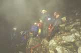
Using the GPS, map, compass and a fair amount of grunting, we finally break into a small rocky clearing on the steep slope - and see a light stick waving at us - YES!
It is now just before 11 pm. Since Ian is an EMT, he takes over patient care, and I'm left to do what I'm qualified for: clearing brush (in preparation for helicopter operations).
Nearing 8 hours of some rather extreme mucking about on a steep, tangled mountainside, I'm getting a bit blurry... so I think; "MAST UH60 Blackhawk" hmmm, this is no little bird - gonna get breezy... and since they're going to be using Night Vision Goggles; no light except light sticks.
So... I take my helmet off, put on a balaclava, put my helmet back on... oops, goggles! Off comes the helmet and balaclava, on go the goggles, helmet and balaclava back on... rats, radio boom mike/earpiece! Off comes the helmet, balaclava, goggles and on goes the boom mike/earpiece, goggles, balaclava and helmet... you get the idea.
By midnight the Blackhawk is in the area, I position the subject near the edge of the clearing, sitting downhill, with his head tucked between his knees. Ian and I are out in the little clearing waving our little light sticks at the big, dark ship.
Once the mighty bird is locked in a hover about 30' above us, things begin to get frisky... the rotor wash is in excess of 80 mph, and we're standing (ya, right) on loose, snow covered rocks with the whole world blowing madly around us - trying to watch for the PJ (Pararescue Jumper) coming down on a cable - in the dark.
The PJ, strapped to a jungle penatrator, hits the deck and yells for us to bring the patient to him. Ian is closest, and I stumble right behind, the subject stands up - and is blown down flat on his back. We each take an arm and haul him to the penatrator, sit him down and strap him on. The PJ yells "we're outta here right... (leans across and wraps his arms around the subject) NOW!" and they pendulum up into the darkness.
We are left crouching and shivering as they are hoisted to the ship - it seems to take forever - a final intense blast of rotor wash, and the ship is gone... an eerie silence replaces the chaos.
Now there is the small matter of climbing that 1/4 mile, and 500 vertical feet through the brush, to the road where the rest of the team waits. Followed by the 3 or 4 mile hike to our pick up point.
We arrive at Search Base a bit after 4 am - hot coffee and food complete the more than 12 hour mission. We later learn the subject is home from the hospital, and in bed before we get out of the woods... cool.
40' Falls - 8/17/97
A 19 year old male fell from a log a considerable distance near the 40' Falls area of Rock Creek, resulting in a collapsed lung, broken ribs and various contusions.
By the time we were called, the paramedics had packaged him, but were unable to get him up the cliffs along the creek.
Since he was already packaged in a stokes stretcher, all the stokes team had to do was adapt our system to their litter, and beef up the packaging for ropes work. The ropes team, meanwhile, had establish the main and belay anchors for the 3 to 1 raising system.
Once he was up, he was carried to the ambulance for the short trip to an open area. A landing zone was quickly established, and within 12 minutes LifeFlight had landed, providing a quick ride to the hospital.
The subject made a complete recovery!
Boy Scout - 8/16/97
Recently a family's home had been invaded by a bat, a bat who's death was followed by testing which showed it to be rabid.
When the results were in, the 14 year old boy was out... on a 5 day, 50 mile hike along the Pacific Crest Trail with his Scout Troop.
Us SAR types were then sent in to find their camp, and bring him out to the nearest road for transport to begin treatment.
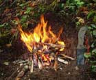
After about 2 1/2 hours of tromping along the rather nice section of trail, under rather nice near-full-moonlight, we came across a peaceful campsite near a creek, with the embers of a campfire still smoldering... all of which changed to total chaos as soon as the dog woke up.
Once things were settled down and somewhat sorted out, we escorted the lad and a couple of the troop leaders to where a deputy was waiting to get him to where he needed to go...
A rather cute mission!
Bear Slayer - 8/9/97
A gentleman in his early 40's was out with friends doing a bit of bear hunting. A bear was spotted below in a recently clear cut ravine, and shot from the road. Rifles were quickly stowed, and he and a companion headed down with handguns to find the bear.
He walked past the bear without seeing it, and was charged from behind. The bear got a good hold on his left calf so he fired his .44 three times at the bear. One shot went through his right foot.
The paramedics had attended to his immediate medical needs. The SAR team's job was to get him up to the road, and the waiting ambulance.
Team members got the stokes stretcher to him and began packaging him for the trip. Others established an anchor for a 3 to1 raising system and belay on vehicles at the road, while another system was being set up about half way between.
A group of Civil Air Patrol Cadets out of Vancouver, WA had been training in the area and arrived to help. They joined in the trail clearing effort along with a DNR crew which had been working near by.
The ropes reached the stokes team and the raising began. Three stokes attendants attached to the stretcher maneuvered over, around and through the ground clutter as the raising system pulled them up the slope.
It was a great example of team work, and all but the rather small bear survived the ordeal.
Dynamite Cave - 7/97
Skamania County has many caves (mostly lava tubes) scattered about in the forest. One occasion I had poked around the first part of Dynamite Cave, up to a 15' drop, and was impressed with what I had seen.
Now Kathleen, Dennis and I were intent on seeing what lay beyond. The first drop of 15' was easily navigated with a caving ladder; which we retrieved as we knew the next drop was 40'... interesting enough with a 36' ladder.
We soon found ourselves in what is called The Ballroom. A fantastic wide passage with a level floor and vaulted ceiling of solid lava.
As The Ballroom narrowed, our way was blocked by the Wood Pit, a 50' hole in the floor, extending from wall to wall.
Next time we'll bring half an aluminum extension ladder (correctly anchored and belayed, of course* - SAFETY FIRST.) to use as a bridge... and see what's next!
* Note: There are other methods developed by cavers for safely crossing holes and other obstacles. Learn and practice methods and techniques BEFORE you take them into the field!
Indian Race Track - 6/14/97
With the snow slowly melting from the higher elevations, I find myself anxious to continue exploring the magic of Indian Heaven Wilderness...
Saturday, while scouting for an area to conduct this coming weekend's SAR training, I couldn't help but notice how close I was to the Indian Race Track (R8E, T5N, section 5). Knowing that trail #171 (dropping in (up?) from the north) would still be snowed in, it seemed only natural to head cross-country on a 51 degree true bearing.
The climb from about 3200' on the 300 road headed up through vine maple tangles and smaller timber. This gradually (thankfully) gave way to bigger trees and less ground clutter.
Upon reaching the top of the ridge (about 4400') the Indian Race Track came into view below.
The meadow containing the race track is half under spring melt water... even so, the peace and quiet is worth the wet feet!
As spring continues to free more of the forest from the snow, the hiking will just keep getting better... who knows; perhaps the Big Lava Bed requires a couple of return trips....
Memorial Day '97
Our SAR Team Coordinator called at 6 am to mention that a couple of teenage boys were over-due from a camping trip above Cascade Locks OR, and would we be good enough to nip over and take a look?
Glancing quickly outside, I was of the opinion that not much would come of it as the day was nice and clear – but not too hot... just not the sort of weather we're used to for a SAR mission.
SAR Base was at the Herman Creek Campground Trailhead, so... at some 7 minutes after 7 am, our search team of three started motoring (south) up what's called the 408 trail, and motored, and motored from about 800' to about 4200' where we engaged the services of some snow to make the cross country trip (east) to meet another team more interesting.
This other team (ESAR 2) had been following some tracks down (north) from the Rainy Lake area to the edge of the world above the Gorton/Harphon creek ravines.
'Bout the time we'd split up and worked our way into the ravines to a series of cliffs, the subjects were believed to have been spotted by a fixed wing aircraft – well below us – between a couple of fetching waterfalls (and their associated cliffs) on Gorton Creek.
With the team in somewhat less-than-optimal condition, and the ground dropping sharply vertical, there was just no way we could negotiate the terrain safely to git to 'em... so we up-and-overed a couple of ridges, pause to pump some water from Harphon Creek (Katadyn® MiniFilter), and eventually made our way up to the 411 trail.
Channel 6 News (Portland, OR) sent in their chopper to use its cameras to verify the identity of the spotted campers, then the 304th Air Force Reserve sent a UH-60 Blackhawk out to see if it could be of some service
On our way down, we heard a SAR type had been injured trying to reach them from the bottom. Then we heard 'em request an ALS RAT (Advance Life Support, Reach and Treat)... at which point I opted for the dreaded "full gear, dead run" method of decent.
Upon panting (wheezing, gagging, coughing, etc.) into the Wyeth Campground (Secondary SAR Base) I was told they had enough folks working the problem and would I like a sandwich? This was at about 7:30 pm.
The team was soon reunited, unloaded, sandwiched, and motored by Bob (a team mate) back to Base. There we heard the 304th had lowered 2 crew members to the campers-in-question, and planned to spend the night there. In the morning they'd rope 'em down.
Wasn't long after that the call came for help with the evacuation of the injured Rescuer, and would any of us be interested?
So back to Wyeth we went, to participate in a fairly short (distance) but remarkably brutal stokes event entailing such diverse elements as Gorton Creek, rock walls, rock drop-offs, dirt w/moss banks, 40º–45º hard snow banks (terminating in the afore-mentioned Gorton Creek), more rocks, some brush... and finally the stokes wheel and a nice wide trail... piece o' cake!
All the festivities ended, and we found ourselves back home just in time to enjoy the arrival of 11 pm.
Other 'n that, it was just another Memorial Day...
Rain Fest - 4/19/97
Each year Stevenson, Washington hosts a Festival of the Rain which enables otherwise normal (?) folks to express, in odd, assorted ways, just how they feel about our rather high annual precipitation.
For the entire history of this festive occasion (going on two years), Wind River Search and Rescue has joined with the community to celebrate the soggy!
This year the team obtained permission to do a rope rescue demonstration off the Port Building; thrilling a hushed crowd of at least a dozen saturated citizens and their pets. The excitement began as two volunteers rappelled from the roof. As they unclipped and prepared the landing area, a stokes litter began its fearless decent.
Once on the ground the litter accepted the "patient"; a nearly convincing replica of an actual person (seeming, sadly, beyond hope). With the patient strapped inside, and a volunteer strapped on the outside, the stokes was hoisted breathtakingly to very near the very top of the building.
Immediately following this, the stokes was, in fact, lowered to the ground.
Later, road flares and a smoke grenade lured a Life Flight helicopter in for a landing at the nearby parking lot for some hands-on training for searchers.
At the end of the day; there was not a dry person to be found!
North Butte - 4/6/97
Immediately east of where the Wind River Hwy closes is the North Butte (section 10, R7E, T5N). Some webbing is used for an arm rappel down 15+ ft. of the freshly eroded west bank of the Wind River. A convenient bridge over the tumbling water is provided by a fallen tree.
The ascent of 1200-1400' is aided by the trusty ice ax (even without snow and ice); hooking tree trunks, branches, and anchoring in fallen timber.
The climbing is rewarded with the ever-changing view of the Wind River Valley through the trees. As the first of the rocky outcroppings leading to the top are reached, the view expands to include the clouds billowing over the crater rim of Mt. St. Helens, peeking from behind the ridges of the Cascade Range.
From the top the view to the northeast includes the backbone ridge of Indian Heaven, with Mt. Adams beyond. Barely discernible in the clouds of the distant northern horizon is the double sno-cone summit of Mt. Rainier, and, to the west of that, a clear view of the sparkling spring snow covering the remaining mass of Mt. St. Helens.
The descent of the 40-50 degree flank of the butte is both assisted and resisted by the tangle of vine maple; providing a "vegetable belay" as well as tripping, snagging and slapping...
The same bridge crosses the Wind River, and the webbing gives a helping hand-over-hand up the bank. The car, and home await... as do the Middle Butte... and South Butte...
Catherine Creek - 3/29/97
Just west of Lyle, Washington, is a parking area behind Rowland Lake. From there it's a short hike into the vertical walled canyon containing Catherine Creek. The view from the canyon rim is clearly worth the effort of the climb; Mt. Hood presides over the rolling, meadowed hills as the Columbia River works its way through the Cascade Mountains via the Columbia River Gorge. Tracy Hill awaits exploration a bit to the north.
The changing seasons always brings magic to the Cascades, and spring has brought a lush green to the area, with just a hint of the explosion of wildflowers soon to come!
My advice is, as usual, Take a Hike!!
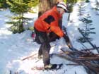
Dog Mountain...
... is the scene of our Tuesday evening hike... At 6 pm we (whoever is interested) meet at the Dog Mountain Trailhead parking lot for an evening of tromping up and down which ever trail(s) strikes our fancy.
Members of Wind River Search and Rescue use this as an unofficial training session, giving us an opportunity to gear up (full search gear = 30-45 lbs) and get a bit of a workout. The nights festivities also allow us to practice SAR fundamentals and share equipment and operational ideas.
|
|
|||||||
|
|||||||
|
509/427-4181 • Fax 509/427-5260 © 2003, Riverside Graphics |
|||||||

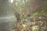
 One rainy afternoon my new knife, metal match and I took a walk in search of a fire —